Barabolar Project
The Barabolar Project is located in central New South Wales, approximately 26 kilometres east of Mudgee and 10 kilometres northwest of the Company’s Bowdens Silver Project.

Location of Barabolar Project
Barabolar Geology and Copper/Molybdenum Anomalism
Extensive surface program within the project area including geological and structural mapping, soil and rock chip geochemistry has been carried out. The geological structural analysis was significantly aided by high resolution aerial magnetics and radiometrics flown by the Company in late 2016.
The Barabolar project extends from the historic Bara silver mine in the south to beyond the Botobolar molybdenum workings to the north. In addition, the Mt Laut quarry previously mined pyrophyllite (an aluminium silicate mineral), which is considered as a strong distal indicator of high sulphidation epithermal mineralisation associated with porphyry related copper-gold systems.
Geologically the Barabolar project consists of several intrusive phases including diorite and quartzolite intruding Ordovician stratigraphy consisting of volcanics, shales, and calcareous mudstones (replaced with skarn mineralisation). Mineralisation is observed in the volcanics (indicating the potential for volcanic hosted massive sulphide mineralisation); the skarn for epithermal mineralisation; and the intrusive rocks for porphyry related mineralisation. The Ordovician stratigraphy of this area is the eastern most representation of the Macquarie Arc that hosts the world-class Cadia-Ridgeway copper-gold mine. However, it is also possible that Permian age mineralisation, related to the nearby Bowdens silver deposit, is also represented in the Barabolar area. In research collaboration with the University of New South Wales to investigate the sources of mineralisation, results to date indicate that the main mineralising event is from an intrusive (porphyry) source not exposed at surface.
Rock chip sampling in the Barabolar area continues to return areas of specific interest. Recent rock chip samples retrieved from the Bara area from a newly discovered exposure of the Bara Silver Mine mineralisation, has returned assays including 10.3% zinc and 6.4% lead, 252g/t silver, 0.16g/t gold and 0.19% copper. These rock chips both validate the high grade polymetallic nature of the Bara area mineralisation, as well as establishes a clear orientation for which to target drilling.
The Company has recently completed an 30-line kilometre dipole-dipole Induced Polarisation (IP) geophysical program including the collection of both chargeability and resistivity data. Tbis was in designed in follow-up to outstanding surface results over a 9,000 metre mineralised corridor with surface geochemistry anomalies in copper, silver, molybdenum, lead and zinc. A series of outcropping mineralised skarns have been mapped over an area 5,000 metres by 800 metres.
The survey was completed by Fender Geophysics and modelled and interpreted by GeoDiscovery Group and the Company’s own geological team. Areas of high chargeability are interpreted to represent accumulations of sulphide mineralisation whereas the resistivity is potentially indicative of increased quartz veining and silicification. The IP survey has generated at least 10 targets that are coincident or proximal to surface anomalism.
 Barabolar Induced Polarisation Survey and recent rock chips on geology
Initial processing of the IP data into 2D format has been completed and further details along with 3D format analysis is expected to be carried out in the coming weeks.
Several chargeability anomalies (inferred to be sulphide accumulations) as illustrated in the cross-sections of the IP data, are coincident with skarn mineralisation and anomalous copper, zinc and silver in the soil sampling. The convergence of datasets, namely the geophysics, the geochemistry, and the geological and structural mapping are producing a series of clear targets for various deposit styles from surface to below 300 metres depth.
Areas of high chargeability, high resistivity and mapped skarn are providing targets directly for skarn related mineralisation. This is illustrated, for example, on chargeability section 6399400N and section 6397000N where skarn mineralisation is coincident with zones of very high chargeability.
Areas of low resistivity, high chargeability and copper anomalism are providing targets directly for porphyry related mineralisation. Further details of chargeability and resistivity will be provided shortly with the completion of 2D and 3D processing and interpretation.
In total, at least 10 preliminary high-order targets have been identified and these are currently being prioritised for further work.
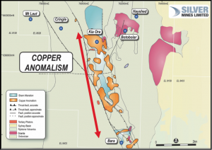 Copper anomalism > 100ppm in soils at Barabolar
 Molybdenum anomalism > 5ppm in soils at Barabolar
 Zinc anomalism > 100ppm in soils at Barabolar
 Lead anomalism > 50ppm in soils at Barabolar
 Silver anomalism > 300ppb in soils at Barabolar
 Barabolar schematic cross section.
Planned Drill Testing
Due to the number of high-order target zones, the Company is planning a comprehensive initial drilling program of up to 7500 metres of reverse circulation and diamond core drilling. Broad targets will be initially tested with shallow drill holes over 10 targets with 3 to 5 holes per target in a program amounting to up to 5,000 metres of drilling. Specifically, targeted deeper holes (minimum 250 metres in depth) totalling approximately 2500 metres will also be undertaken. Subject to planning and approvals, drilling is expected to commence in September 2018.


